Savar Upazila
"Savar" redirects here. For the villages in Iran, see Savar, Iran (disambiguation). For the locality situated in Västerbotten County in Sweden, see Sävar.
Savar or Shabhar
সাভার
সম্ভার Shômbhar |
|
| Upazila |
|

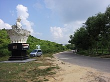
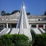
National Memorial in Savar, Bangladesh
|
|
|
Location in Bangladesh |
|
| Coordinates: 23°51′30″N 90°16′00″ECoordinates: 23°51′30″N 90°16′00″E |
|
| Country |
 Bangladesh Bangladesh |
|
| Division |
Dhaka Division |
|
| District |
Dhaka District |
|
| Area |
|
| • Total |
280.13 km2 (107.50 sq mi) |
|
| Population (2011) |
|
| • Total |
1,387,426 |
|
| • Density |
4,951/km2 (12,820/sq mi) |
|
| Time zone |
BST (UTC+6) |
|
| Post code(s) |
134.. |
|
| National calling code |
+880 |
|
| Calling code |
027 [For Savar only] |
|
Savar (
Bengali: সাভার Savar or Shabhar) is an
Upazila of
Dhaka District in the
Division of Dhaka, Bangladesh.It is located at a distance of about 24 kilometres (15 mi) to the northwest of
Dhaka city. Savar is mostly famous for
Jatiyo Smriti Soudho, the National Monument for the Martyrs of the
Liberation War of Bangladesh.
- 1 History
- 2 Geography
- 3 Demographics
- 4 Economy
- 5 Administration
- 6 Politics
- 7 Education
- 8 Important institutions
- 9 See also
- 10 References
History
The origin of the name
Savar is thought to be an evolved version of the ancient 7th-8th century township of
সর্বেশ্বর Shôrbeshshôr (
"Lord of everything") or সম্ভার
Shômbhar
("Collection") situated on the banks of the river known today as the
Bangshee. It was the capital of the Sanbagh Kingdom then. Local legends
claim that a king by the name of Harish Chandra ruled over
Shôrbeshshôr. There is an old
shloka that goes
বংশাবতীর পূর্বতীরে সর্বেশ্বর নগরী, বৈশে রাজা হরিশচন্দ্র জিনি সূরপুরী Bôngshabotir purbotire shôrbeshshôr nôgori, boishe raja Horishchôndro jini shurpuri ("In Sharbeshvar city on the east bank of the
Bansabati, lives King Harish Chandra conquering Heaven").
During the
1971 war,
Savar Cantonment (then Ansar Camp) and the then-newly founded
Jahangirnagar University were some of the first targets of military swoop outside the capital following
Operation Searchlight of 25 March. In December of that year, Savar was the last obstacle before the freedom fighters (led by
Kader Siddiqui
and others) entered the capital and the Pakistan army conceded defeat.
Days before the end of the war, teenager Golam Dastagirr Titu was killed
in a direct encounter between the Pakistani army and the freedom
fighters. The compatriots buried him near the main gate of the Central
Cattle Breading & Dairy Farm, Savar. The Bangladeshi army
constructed a memorial monument in his honour.
On 24 November 2012, a garment factory fire killed at least 112
people. The factory made clothes for US and European companies and was
faulted for negligent safety standards. Walmart and Sears, two of the companies who contracted work from this factory, refused to compensate victims.
On April 24, 2013,
a building in Savar collapsed, killing 1,129 people and injuring around 2,500.The building housed a garment factory which exported clothing to US and
European companies. Eighty percent of the workers were women aged
18–20, paid $0.12-$0.26 per hour.
Geography
Savar is located at
23.8583°N 90.2667°E.
It has 66,956 units of household and a total area of 280.13 square
kilometres (108.16 sq mi). It is bounded by
Kaliakair and
Gazipur Sadar
upazilas on the north,
Keraniganj upazila on the south,
Mirpur,
Mohammadpur,
Pallabi and
Uttara thanas of Dhaka City on the east, and
Dhamrai and
Singair upazilas on the west. The land of the upazila is
composed of alluvium soil of the Pleistocene period. The height of the
land gradually increases from the east to the west. The southern part of
the
upazila is composed of the alluvium soil of the
Bangshi and
Dhalashwari rivers. Main rivers are
Bangshi,
Turag,
Buriganga and
Karnatali. The
Bangshi River has become polluted due to industrial. The
total cultivable land measures 16,745.71 hectares (41,379.6 acres), in
addition to fallow land of 10,551.18 hectares (26,072.5 acres).
Demographics
As
of the 2011 Bangladesh census,
Savar Upazila had a population of
1,387,426. Males constituted 54.20% of the population, and females
45.80%. This Upazila's eighteen-up population was 207,401.
Savar had an
average
literacy rate
of 58.16% (7+ years), and the national average of 54.4% literate. Male
literacy was 64% and female was 51%. The religious breakdown was
Muslim 88.59%,
Hindu 10.41%, Christian 0.93%,
Buddhist 0.03% and others 0.04%, and ethnic minority group nationals numbered 319 including
Buno,
Garo, Chakma (Sangma), and
Burman.
The main occupations are Agriculture 24.34%, agricultural labourer
12.84%, wage labourer 4.44%, cattle breeding, forestry and fishing
1.90%, industry 1.37%, commerce 17.35%, service 20.68%, construction
1.66%, transport 3.96% and others 11.46%.
Economy
Agriculture
and manufacturing are the two major economic sectors in
Savar. The main
crops grown here are Paddy, Jute, peanut, onion, garlic, chili and
other vegetables. The extinct or nearly extinct crops in the region are
Aus paddy,
Asha Kumari paddy, sesame, linseed,
kali mator,
randhuni saj,
mitha saj, kaun and mas kalai. The main fruits cultivated here are
Jackfruit, mango, olive, papaya, guava,
kamranga, berry and banana.
There are 181 combined fisheries, dairies and
poultries Dairy, 5
hatcheries, 209
poultries, and 1319 fisheries. Manufacturing facilities
include Ceramic industry, beverage industry, press and publication,
garments industry, foot ware, jute mills, textile mills, printing and
dying factory, transformer industry, automobile industry, biscuit and
bread factory, pharmaceutical industry, soap factory, brick field, cold
storage, welding, plant nursery, etc.
Bangladesh Export Processing Zone
is located in this
upazila. The Cottage industry includes 8 Weaving,
100 goldsmith and 29 others workshops. The main exports are
Jackfruit,
papaya, flower, sapling, dairy products, meat, transformer, fabrics,
dye, medicine, ready made garments, electronics and electric goods,
shoe, brick, sweetmeat etc.
There are 62 km of
pucca (first-class), 56 km of semi
pucca,
562 km of mud road; and 50 km of highway. Transports used here include
the traditional (and extinct or nearly extinct) Palanquin, bullock cart
and horse carriage as well as modern day vehicles.
The minimum wage is approximately $9.50 per week, or $38 per month.
Administration
Savar
has 13 Unions/Wards, 350
Mauzas/Mahallas, and 321 villages. The
municipal area (
Savar Town) consists of 9 wards and 55
mahallas. The
area of the town is 24.1 km². It had a population of 124,885; male
53.03%, female 46.97%; population density per km² of 5182. Savar Thana
was established in 1912 and was turned into an Upazila in 1983.
Presently
Savar Upazila divided into to 2
thanas, one is
Savar Main and
other is
Ashulia.
Savar Adhar Candra Model High School established on 10 January 1913 by
Mr.Rakhal Chandra, is one of the oldest educational institutes in Bangladesh
Politics
Several Hindu families played a critical role in the development of
the township during the British Raj in the 19th and first half of the
20th century. After partition of India in 1947, the Hindu influence in
the area waned following the departure of many prominent Hindu families.
The 1960s saw the establishment of some important institutions,
including a dairy farm and a University in the area. Concurrently,
communist politics was on the rise in the area. However, this was
replaced with Bengali nationalist zeal, when the
Bangladesh Awami League
won the 1970 election in this constituency. In 1975, Savar came to the
spotlight when the Maoist leader
Shiraj Shikdar was secretly tortured
and executed at
Savar Cantonment. Savar was politically important to the
military dictators of the mid-1970s and 1980s, as the cantonment armory
here was the closest one outside the capital.
From the 1990s to mid-2000s, the
Bangladesh Nationalist Party
candidate has been routinely elected to parliament from this
constituency. However, Bangladesh Awami League and other parties;
Communist Party of Bangladesh,
Socialist Party of Bangladesh,
Worker's Party (
Menon), National
Awami Party,
Sammobady Dal (including
several Islamist ones) continue to have grassroots presence. The general
election at the end of 2008 saw an Bangladesh Awami League candidate
elected to parliament from this constituency.
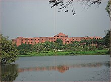
Jahangirnagar University
and a few colleges in the area serve as a hotbed of active student
politics and strife. Foreign dignitaries customarily visit Savar as a
part of their trip to Bangladesh to pay respect to
the martyrs of 1971 at the
Jatiyo Smriti Soudho.
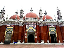
Central Mosque at Jahangir Nagar University, Savar
Effluent Treatment plant at Savar
Open theatre at Jahangirnagar University
Jahangirnagar University hostel
Education
There
are
3 universities,
5 colleges,
6school and colleges,
38 high schools,
3
junior high schools,
16 madrasas,
88 government primary schools,
13
non-government primary schools,
12 community schools,
8 satellite
schools, and
1 sports institution. Some of the noteworthy institutions
are Adhar Chandra High School (established in 1913),
Gana
Bishwabiddalay, Bangladesh
Krira Shikha Institution,
- Jahangirnagar University, a Public University, along with its School and College
- Army Institute of Business Administration(AIBA), an Army Run Educational Institute under Public University (BUP)
- Savar University College Affiliated The National University Of Bangladesh (NU)
- Asian University of Bangladesh, a Private University
- Abdul Mannan Degree College Affiliated The National University Of Bangladesh (NU)
- Gono Biswabidyalay, a Private University
- Savar Model College& a Secondary Higher School.
- Savar Cantonment College& a Secondary Higher School.
- Savar Adhar Chandra High School, A secondary Higher School.
- B.P.A.T.C School and College (Bangladesh Public Administration Training Centre)
- Enam Medical College and Hospital (founded by Mp Enam).
- {Nightengle Medical College},(Sarker market)
- Savar Laboratory School and College Savar Laboratory Junior School
- Katlapur pre-cadet school
- Zirabo Cantonment School and College.
- Siraz memorial school & college.
- Gazirchat A.M.School And College.
- Millenium Kindergarten & High school (founder by Delwar Sarker).
- Gumail School & College (established by Nobi Sarker).
- Yearpur High School.
- Zirabo Dewan Idris College.
- Ashulia College.
- BRACK University.
- City University.
- Chakulia High School, Chakulia, Savar, Dhaka
- Gakulnagar High School, Gakulnagar,Ashuia,Savar, Dhaka.
Important institutions
The
National Martyrs’ Memorial
is the national monument of Bangladesh, set up in the memory of the
valour and the sacrifice of all those who gave their lives in the
Bangladesh Liberation War of 1971, which brought independence and separated Bangladesh from
Pakistan. The monument is located in
Savar.It was designed by
Syed Mainul Hossain.
DEPZ (Dhaka Export Processing Zone) is located in Savar Upazila, and
was established in 1993. DEPZ is located 35 km from Dhaka city centre,
25 km from
Shahjalal International Airport, and 304 km from Chittagong Sea Port.
Savar is the home of
Jahangirnagar University,
a Public University of Bangladesh and only University for full student
residence facilities which is famous for its scenic beauty and as a
prime destination for Siberian migratory birds during winter.
Army Institute of Business Administration (
Bengali: আর্মি ব্যবসায় প্রশাসন ইনস্টিটিউট) commonly known as
AIBA or
Army IBA is a business school in
Savar Cantonment, Savar. AIBA is run by the
Bangladesh Army
and is under the Ministry of Defense of Bangladesh. AIBA was
inaugurated by the Education Minister of Bangladesh on 5 March 2015. The
institution is affiliated with
Bangladesh University of Professionals, a university governed by the Armed Forces of Bangladesh
The nation's one and only
specialised rehabilitation hospital, the CRP-Bangladesh centre for the
rehabilitation of the paralysed, is located in Savar, about 1 kilometre (0.62 mi) from Savar Bazar.
There are many other important institutions in Savar. The 9th
Division Army Savar Cantonment is located here. There is a military rirm
and government dairy firm beside Jahangirnagar University. BPATC
training center is the only training centre for the public service
commissioned officers in Bangladesh. Radio Bangladesh (
Bangladesh Betar) employers Residence and The Transmission Zone with huge Transmission Setup. (
HPT-1; high power transmission, HPT-2, etc.).
The two Largest entertainment theme parks of Bangladesh namely
"Fantasy Kingdom" and "Nondon Park" are also located here. Fantasy
Kingdom is situated in Jamgora Bazar and Nondon Park is situated in
Jirani.
Bangladesh Krira Shiksha Pratisthan (BKSP), the only national sports institute of Bangladesh is also situated in Jirani Bazar.
There are 318 mosques, 8 churches and 68 other religious
institutions. The Atomic Energy Research Establishment, Satellite Ground
Receiving Station (Talibabad), National Institute of Biotechnology,
Bangladesh Livestock Research Institute, Savar Youth Training Centre.
The locally published newspapers and periodicals are
Jagrata Kantha,
Savar Barta,
Saf Katha,
Savar Kantha, and
Ganabhasa.
The officially registered cultural and social organisations here
include 81 Co-operative societies, 1 children's organisation, 3 film
societies, 5 cinema halls, 5 theatre groups, 1 theatre stage, 3 music
centre, 5 orphanages, 1 opera party (an indigenous travelling theater
troupe), 3 women's club, 1 chapter of Bangladesh Mohila Parishad, 2
Amnesty organisations, 1 golf club, 2 entertainment parks. There are
numerous other unofficial organizations as well. Operationally important
NGOs include Ganasastha Kendra, World Vision, Swanirvor Bangladesh,
VERC, Palli Mangal Karmasuchi, CDD, Adesh, Mother Vision Society of
Bangladesh etc. The health centres in Savar include 1 Upazila health
complex, a combined military hospital (Savar Cantonment), the Korea
Bangladesh Friendship Hospital, 7 family planning centres, 2 satellite
clinics, and 21 private clinics.
The Gono University or Gono Biswobidyaloy is a private university in
Savar. It was established on 14 July 1998 and is popular for its
extraordinary non-smoking rule for students, teachers and staff. It was
one of 11 universities that went operational without University Grants
Commission (UGC) approval which was made a necessity under the Private
University Act (1992). It also introduced new academic courses without
UGC approval along with a number of other private universities.
See also
- Districts of Bangladesh
- Divisions of Bangladesh
- Upazilas of Bangladesh