- 1 Town
- 1.1 History
- 2 Geography and climate
- 3 Important Educational Institutions
- 3.1 Economy and development
- 3.2 Tourist attractions near the town
- 4 See also
- 5 References
- 6 External links
- Himchari National Park : Himchari is located just south of the Cox's Bazar town. It consists of lush tropical rain forest, grasslands and trees, and features a number of waterfalls, the biggest of which cascades down toward the sandy, sun-drenched beach. The National Park was established in 1980 by the Government of Bangladesh as a conservation area for research, education and recreation. Once it was the stomping grounds of herds of Asian elephant. It is still home to a limited number of these mammals.
- Aggmeda Khyang: a large Buddhist monastery, and a place revered by around 400,000 Buddhist people of Cox's Bazar; and the Chittagong Hill Tracts. The main sanctuary is posted on a series of round timber columns. It has a prayer chamber and an assembly hall along with a repository of large and small bronze Buddha images and a number of old manuscripts.
- Ramu ; about 10 km (6 mi) from Cox's Bazar, is a village with a sizeable Buddhist population. The village is famous for its handicrafts and homemade cigars. There are monasteries, khyangs and pagodas containing images of Buddha in bronze, gold and other metals with precious stones. One of the most interesting of these temples is on the bank of the Baghkhali river. It houses not only relics and Burmese handicrafts but also a large bronze statue of Buddha measuring thirteen feet high which rests on a six feet high pedestal. Weavers ply their trade in open workshops and craftsmen make handmade cigars in their pagoda like houses.
- Bangabandhu Sheikh Mujib Safari Park: Bangabandhu Sheikh MujibSafari Park is the first Safari Park in Bangladesh. The nature of the forest is tropical evergreen and rich with Garjan, Boilam, Telsur and Chapalish along with herbs, shrubs and creepers. Safari Park is a declared protected area where the animals are kept in fairly large area with natural environment and visitors can easily see the animal when ever they visit by bus, jeep or on foot. This park was established on the basis of South Asian model. This safari park is an extension of an animal sanctuary located along the Chittagong-Cox's Bazar road about 50 km (30 mi) from Cox's Bazar town. The sanctuary itself protects a large number of wild elephants which are native to the area. In the safari park there are domesticated elephants which are available for a ride. Other animal attractions include lions, Bengal tigers, Crocodiles, Bears, Chitals and lots of different types of birds and monkeys.which is wonder full project to attract the tourist.
- Inani Beach :Inani is a stony beach near Cox's Bazar.
- Cox's Bazar District
- Cox's Bazar Sadar Upazila
- Cox's Bazar Airport
Cox's Bazar
| Cox's Bazar (King of Ocean) কক্সবাজার |
|
|---|---|
| City | |
 |
|

Cox's Bazar
(King of Ocean) |
|
| Coordinates: 21°35′0″N 92°01′0″E | |
| Country | Bangladesh |
| Division | Chittagong Division |
| District | Cox's Bazar District |
| Area | |
| • City | 6.85 km2 (2.64 sq mi) |
| Elevation | 3 m (10 ft) |
| Population (2007 est.)Total population represents population in city and metro represents entire district. | |
| • City | 51,918 |
| • Density | 7,579.27/km2 (19,630.2/sq mi) |
| • Metro | 120,480 |
| Time zone | BST (UTC+6) |
 Part of a series on Tourism in Bangladesh |
||
|---|---|---|
| Beaches | ||
| Cox's Bazar sea beach · Kuakata Patenga St. Martin's Island · Nijhum Dwip |
||
| Hill stations | ||
| Bandarban · Khagrachari · Rangamati Jaflong · Sripur · Srimongol |
||
| Islands | ||
| Chhera island · Bhola · Hatiya Kutubdia · Manpura · Nijhum Dwip Sandwip · Sonadia · St. Martin's Island |
||
| Wildlife | ||
| Sundarbans · Bhawal · Lawachara forest | ||
| Waterfalls | ||
| Hum Hum · Madhabkunda · Nafa-khum Jadipai |
||
| Archaeological sites | ||
| Bhitagarh · Choto Katra Jagaddala Mahavihara Mahasthangarh · Mainamati Mosque City of Bagerhat Noapara-Ishanchandranagar · Sonargaon · Somapura Mahavihara · Wari-Bateshwar |
||
| Architecture | ||
| Ahsan Manzil · Bara Katra · Curzon Hall Jatiyo Sangshad Bhaban Lalbagh Fort · Northbrook Hall |
||
| Religious | ||
| Mosques Sixty Dome Mosque Hindu Temples Kantaji Temple Buddhist Temples Buddha Dhatu Jadi Churches Armenian Church (Dhaka) |
||
| Events | ||
| International mother language day Pohela Boishakh |
||
| National monuments | ||
| Jatiyo Smriti Soudho Shaheed Minar |
||
| Miscellaneous | ||
| Gardens · Lakes · Museums Palaces · Parks · Rivers World Heritage Sites · Zoos |
||
| Bangladesh Portal |
||
The modern Cox's Bazar derives its name from Captain Hiram Cox (died 1799), an officer of the British East India Company. Cox was appointed Superintendent of Palongkee outpost after Warren Hastings became Governor of Bengal. He embarked upon the task of rehabilitating refugees in the area and made significant progress[clarification needed]. Captain Cox died in 1799 before he could finish his work. To commemorate his role in rehabilitation work, a market was established and named Cox's Bazar after him. Unlike many locations in the Indian Subcontinent where name places dating to the colonial period were changed, Cox's name is up to the present retained in the city he founded.
Today, Cox's Bazar is one of the most-visited tourist destinations in Bangladesh, although not a major international tourist destination. In 2013, the Bangladesh Government formed the Tourist Police unit to protect local and foreign tourists better, as well as to look after the nature and wildlife in the tourist spots of Cox's Baza
In 2017, the Kutupalong refugee camp for Rohingya people escaping from Myanmar opened near Cox's Bazar.
Contents
Town
Cox's Bazar Town was constituted in 1869, eventually becoming a B-grade municipality in 1989. Located along the Bay of Bengal in South Eastern Bangladesh, Cox's Bazar Town is a health resort. But it is famous mostly for its long natural sandy beach. The municipality covers an area of 6.85 km2 (2.64 sq mi) with 27 mahallas and 9 wards and has a population of 51,918. Cox's Bazar is connected by road and air with Chittagong.History
The greater Chittagong area, including Cox's Bazar, was under the rule of Arakan kings from the early 9th century until its conquest by the Mughals in 1666 AD.When the Mughal Prince Shah Shuja was passing through the hilly terrain of the present-day Cox's Bazar on his way to Arakan, he was attracted to its scenic and captivating beauty. He commanded his forces to camp there. His retinue of one thousand palanquins stopped there for some time. A place named Dulahazara, meaning "one thousand palanquins," still exists in the area. After the Mughals, the place came under the control of the Tipras and the Arakanese, followed by the Portuguese and then the British.The name Cox's Bazar originated from the name of a British East India Company officer, Captain Hiram Cox, who was appointed as the Superintendent of Palonki (today's Cox's Bazar) outpost. He succeeded Warren Hastings, who became the Governor of Bengal following the British East India Company Act in 1773. The Captain rehabilitated many refugees in the area, but died in 1799 before he could finish his work. To commemorate him, a market was established and named after him, called Cox's Bazar. Cox's Bazar then was first established in 1854 and became a municipality in 1869.
After the Sepoy Mutiny (Indian Rebellion of 1857) in 1857, the British East India Company was highly criticised and questioned on humanitarian grounds, specially for its opium trade monopoly over the Indian Sub-Continent. However, after its dissolution on 1 January 1874, all of the company's assets including its Armed Forces were acquired by the British Crown. After this historic take over, Cox's Bazar was declared a district of the Bengal Province under the British Crown.

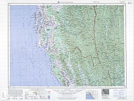
Cox's Bazar Map
from Series U542, US Army Map Service, 1955
In 1961 the Geological Survey of Pakistan initiated investigation of radioactive minerals like monazite around the Cox's Bazar sea-beach area.

Cox's Bazar Bus Terminal
After the independence of Bangladesh, Cox's Bazar started to get administrative attention. In 1972 the town committee of Cox's Bazar was turned into a municipality. In 1975, The Government of Bangladesh established a pilot plant at Kalatali.Later, in 1984 Cox's Bazar subdivision was promoted to a district, and five years later (in 1989) the Cox's Bazar municipality was elevated to B-grade. In 1994 (jobs) the Marine Fisheries and Technology Station (MFTS) was established at Cox's Bazar. MFTS is a research station of Bangladesh Fisheries Research Institute (BFRI) headquartered in Mymensingh. The station covers a land area of four hectares and contains five laboratories.In April 2007 Bangladesh got connected to the submarine cable network as a member of the SEA-ME-WE-4 Consortium, as Cox's Bazar was selected as the landing station of the submarine cable.In September 2012 the municipality was the site of the Cox's Bazar and Ramu riots, where local Muslims attacked the Buddhist community over an alleged Quran desecration posted to Facebook.
Geography and climate

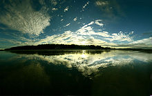
Panorama of Cox's Bazar in the early morning: clouds on a blue sky, still water and forest in the distance.
The climate of Bangladesh is mostly determined by its location in the tropical monsoon region: high temperature, heavy rainfall, generally excessive humidity, and distinct seasonal variations. The climate of Cox's bazar is mostly similar to the rest of the country. It is further characterised by the location in the coastal area. The annual average temperature in Cox's Bazar remains at about a maximum of 34.8 °C (94.6 °F) and a minimum of 16.1 °C (61.0 °F). The average amount of rainfall remains at 3,524 mm (138.7 in).
| [hide]Climate data for Cox's Bazar | |||||||||||||
|---|---|---|---|---|---|---|---|---|---|---|---|---|---|
| Month | Jan | Feb | Mar | Apr | May | Jun | Jul | Aug | Sep | Oct | Nov | Dec | Year |
| Record high °C (°F) | 32.8 (91) |
33.9 (93) |
36.1 (97) |
37.2 (99) |
35.0 (95) |
36.1 (97) |
33.3 (91.9) |
33.3 (91.9) |
34.4 (93.9) |
33.9 (93) |
33.3 (91.9) |
31.7 (89.1) |
37.2 (99) |
| Average high °C (°F) | 26.7 (80.1) |
28.5 (83.3) |
30.9 (87.6) |
32.1 (89.8) |
32.3 (90.1) |
30.7 (87.3) |
30.0 (86) |
30.2 (86.4) |
30.9 (87.6) |
31.6 (88.9) |
30.0 (86) |
27.5 (81.5) |
30.1 (86.2) |
| Average low °C (°F) | 15.0 (59) |
17.0 (62.6) |
20.7 (69.3) |
23.9 (75) |
25.1 (77.2) |
25.2 (77.4) |
25.1 (77.2) |
25.0 (77) |
25.0 (77) |
24.3 (75.7) |
21.1 (70) |
16.5 (61.7) |
22.0 (71.6) |
| Record low °C (°F) | 7.8 (46) |
9.4 (48.9) |
11.1 (52) |
16.1 (61) |
16.7 (62.1) |
20.6 (69.1) |
21.7 (71.1) |
19.4 (66.9) |
21.7 (71.1) |
17.2 (63) |
13.3 (55.9) |
8.9 (48) |
7.8 (46) |
| Average precipitation mm (inches) | 4.1 (0.161) |
17.0 (0.669) |
34.7 (1.366) |
121.8 (4.795) |
286.8 (11.291) |
801.9 (31.571) |
924.6 (36.402) |
667.1 (26.264) |
330.1 (12.996) |
213.6 (8.409) |
109.4 (4.307) |
13.0 (0.512) |
3,524.1 (138.744) |
| Average precipitation days | 1 | 2 | 3 | 6 | 13 | 19 | 22 | 21 | 14 | 7 | 4 | 1 | 113 |
| Average relative humidity (%) | 72 | 71 | 75 | 78 | 80 | 87 | 89 | 88 | 86 | 82 | 77 | 74 | 80 |
| Source #1: Bangladesh Meteorological Department | |||||||||||||
| Source #2: Deutscher Wetterdienst (extremes) | |||||||||||||
Important Educational Institutions
1962: Cox's Bazar Govt. College is the earliest Secondary and bachelor's degree offering college founded in Cox's Bazar.1985: Cox's Bazar Law College is the first profession based college founded in this district.
1991: Cox's Bazar Govt. Women's College is the first Secondary and bachelor's degree offering college in this district solely for women.
2008: Cox's Bazar Medical College is the first medical college in this district and 200 bedded hospital
Other Colleges in this area: Cox's Bazar City College, Ramu Degree College, Ukhiya Degree College, Teknaf Degree College, Moheskhali degree college
High Schools: Cox's Bazar Govt. High School, Cox's Bazar Govt. Girls High School, Cox's Bazar Model High School, Kishalaya Model High School, Chokoria, Korak Bidda-pith, Chokoria, Chokoria Govt. High School, Palong Model High School, Shilkhali High School, Pekua.
Economy and development

Bangladesh
|
|
| Location | Cox's Bazar Bangladesh |
|---|---|
| Coordinates | 21°25′53″N 91°58′42″E |
| Year first constructed | n/a |
| Foundation | concrete base |
| Construction | metal skeletal tower |
| Tower shape | square prism skeletal tower with balcony and lantern |
| Markings / pattern | white tower, orange lantern |
| Height | 7 metres (23 ft) |
| Focal height | 54 metres (177 ft) |
| Range | 21 nautical miles (39 km; 24 mi) |
| Characteristic | Fl W 15s. |
| Admiralty number | F1056.4 |
| NGA number | 26756 |
| ARLHS number | BAN-001 |
| Managing agent | Bangladesh Department of Shipping |
 Submarine Cable Landing Station:
Submarine Cable Landing Station
People are also involved in fishing and collecting seafood and sea products for their livelihood. Oysters, snails, pearls and their ornaments are very popular with tourists. Some people are involved in the transportation business for tourists. Cox's Bazar is one of the few major spots for aquaculture in Bangladesh.Along with Khulna, it is considered a major source of revenue from foreign exchanges. Beside a mix of small-scale agriculture, marine and inland fishing and salt production are other industrial sources that play important roles in the national economy.
Tourist attractions near the town
 Beach-side
Beach-side accessories for the tourists at Cox's Bazar

No comments:
Post a Comment